Research Focus on Dr. Raymond Torres
Floodplains, currents… and so on…..
If you recall the opening scene from the movie “The Revenant,” the group of hunters led by Leonardo DiCaprio was walking through a forested area in search of game. The camera cut to the ground surface and it was apparent that the hunters were walking in rather fast moving but shallow water that was flowing over the forest floor. In fact, they were walking through a partially inundated, forested floodplain. Floodplains are relatively flat lying and often forested areas adjacent to large and small rivers. The larger river/floodplain systems throughout the world can experience 6+ meters of inundation each year and for month long durations, whereas the floodplain of a system like the Congaree River, South Carolina may experience up to 3 meters of inundation for up to a few weeks.
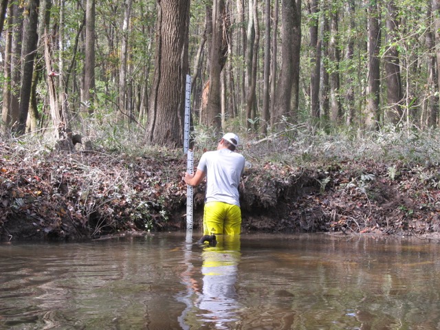
During inundation the surface water flow paths and currents dictate many of the physical and biological functions that allow the floodplain to persist as a vibrant ecosystem. Too much or too little flooding can cause plants to die off. Of equal or greater importance is the hydraulic connectivity, or the degree of connectedness of different subsystems within the floodplain. The level of connectivity is controlled by a changing water level, and as connectivity changes so do the opportunities for nutrient exchange, pathways for fauna, the distribution of larva and seeds, and the spatial and temporal attributes of organic matter accumulation. Hence, connectivity is a dynamic attribute of floodplain systems, and the recurrence of flooding on the floodplain, the duration of flooding and the direction and speed of water flows over the floodplain are critical to allowing the landscape to persist as a robust ecosystem that provides many benefits to society.
As part of a $1M NASA EPSCoR study we will investigate the temporal and spatial variability of flood water circulation over the Congaree River floodplain, at the Congaree National Park, SC. This objective is being met through a three part study that includes radar remote sensing of the water surface elevation over the entire floodplain, direct field measurements of water surface slope, water speed and direction, and 3D numerical simulations of surface water flow. Although this project started in January we already developed the flow domain for numerical simulations, installed field instruments and we have initial maps of water surface elevation. As the study progresses we will to enhance and refine our observations and analyses to provide greater mechanistic insight on the how floodplain currents vary with time and water level, and how that can be expected to change in response to changes in climate and land use. Moreover, results gleaned here are likely transferable to other forested floodplain systems. Hence, this work is relevant to SC and it’s multitude of floodplain systems, especially in the low country, and to floodplains throughout the world that are susceptible to natural and human induced changes to the land surface and climate.
Raymond Torres and Venkat Lakshmi, USC Columbia
Jessica Sullivan, USC-Aiken
Project Title: Temporal and Spatial Variability of Floodplain Currents by In-Situ Observations, Radar Interferometry and Numerical Simulations. Click here to read the NASA EPSCoR Project Abstract.
Click download PDF of Research Focus on Raymond Torres
June 14, 2017